 Here is Peace House Academy from a whole 'nother perspective. While Charles and Andrea were here, we were able to ask a friend with a plane for a favor and he flew them over the school site for this great shot. Unfortunately, when you come to volunteer, we can't promise you'll get this view...but at least you can map out your early morning walking/running routes!
Starting at the bottom, the pairs of squares are the student dorms. Just to the left of them and at an angle is the dining hall. Above them, the egg-shaped road circles the hill--you can see the volunteer housing on the lower right of the loop. At the left on the narrow end, you can see the headmaster's house and our house which is to the right. Along the top of the loop are the teacher houses. Directly to the left of the narrow end of the loop is the administration/clas
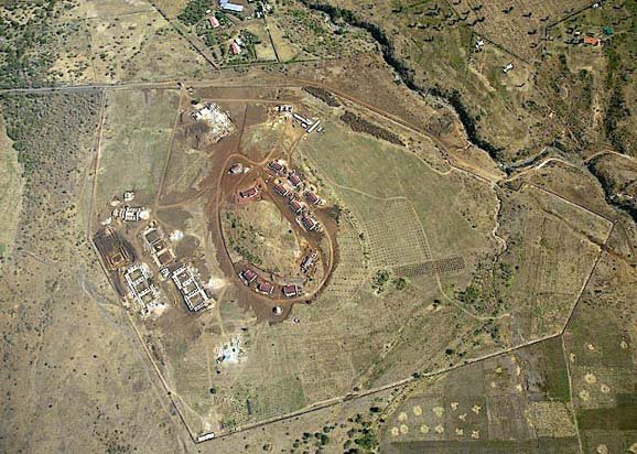 sroom building. Above that is the workshop area.
This view from higher up shows the whole project area. You can see the fence line around the approx. 100 acres. A large section of the land to the right of the loop has been planted as an orchard.
Karibuni wote! (Welcome to all!)


No comments:
Post a Comment